Just like the double dipsea, except you start in Tam Valley and go to Muir Beach. It is ~nine miles round trip from the start point at the bottom of this post; the total vertical climb is ~2,000 feet (1,000 feet each way).
You can extend the run/hike by starting lower in the valley. When I did the run, it was 11 miles total when starting from my house.
For reference, the double dipsea is ~14-15 miles. Ironically, if you started the double dias at the dipsea cafe, it would be ~14-15 miles round trip.


Hello Ocean Beach, San Francisco. And San Pedro Point in the distance.

A dead tree so completely covered in Moss that it still looks live.

The approach.

Early spring flowers...

I love photographing Live Oaks.

The approach. The brilliant white at the top of the photo is the sun reflecting off the ocean.

 Green Gulch Farm
.

Purple flowers blossoming on the trees.
 The Pelican Inn
.


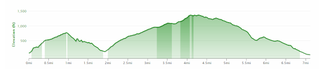
 A Graphical Look at the Trail
 Getting Started
Here is the
Trail Map. You run through the neighborhood until you reach this unnamed connector trail that then takes you up to Shoreline. You could skip this connector and just drive up to Shoreline to get right on the Dias connector
here.